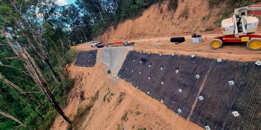
Too many earthmoving contractors in Newcastle push a batter to 45 degrees and assume it will stand. They skip the analysis. Then a summer storm hits Merewether Heights and the whole cut collapses onto the roadway. Our team has reviewed dozens of these failures. The common thread is ignoring pore-water pressure in residual clay profiles. Newcastle’s geology is dominated by Permian coal measures, deeply weathered near the surface, with colluvial blankets draped over steep slopes in suburbs like The Hill and Bar Beach. A desktop review of borehole logs is not enough. You need a CPT test to capture the transition from fill to natural ground, and a proper limit-equilibrium model that respects the actual groundwater conditions. Without that, you are guessing.
A slope that stands today in Newcastle can fail next week if the analysis ignored the perched water table in the colluvium.
Area-specific notes
The field work starts with a tracked CPT rig or a hollow-stem auger drill moving into a steep backyard in New Lambton Heights. Access is tight. The rig has to be winched into position on some sites. We push the cone to refusal, often encountering extremely weathered tuff that reads like soil to the friction sleeve but retains enough structure to cause a false refusal. The real risk is misinterpreting this contact. If the designer places a slip surface tangent to that boundary, the calculated factor of safety becomes meaningless. We cross-check every CPT trace with disturbed samples from an adjacent borehole, running pocket penetrometer tests on the cuttings to confirm the transition depth. In Newcastle’s coastal zone, we also encounter liquefiable sand layers in the paleochannels that run beneath the dunes—these demand a coupled stability-deformation analysis, not a simple static check.
FAQ
What is the typical cost of a slope stability analysis for a residential site in Newcastle?
For a standard Newcastle residential block with a cut or fill up to 4 metres high, the analysis typically falls between AU$1,780 and AU$3,500. That assumes we have existing borehole data and the geometry is straightforward. Larger subdivisions or sites with complex groundwater conditions in suburbs like Merewether or The Hill push the scope into the AU$4,500 to AU$6,940 range, especially when inclinometer monitoring or seismic assessment is required.
How long does a slope stability assessment take from investigation to report?
A typical Newcastle job runs four to six weeks. The first two weeks cover site investigation—CPT or drilling, piezometer installation, and sampling. Laboratory testing of shear strength takes another two weeks. The analysis and reporting phase is one to two weeks, depending on the number of cross-sections we need to model.
Does AS 4678 require a 1.5 factor of safety for all Newcastle slopes?
AS 4678 specifies a minimum factor of safety of 1.5 for permanent cuts and fills under static conditions. For temporary works during construction, we can adopt 1.3. However, Newcastle’s colluvial soils are highly variable. We often recommend a 1.5 target even for short-term cuts if the slope is adjacent to an existing dwelling or public road.
What triggers a slope failure in Newcastle’s coastal suburbs?
Rainfall is the dominant trigger. Intense summer storms saturate the near-surface colluvium, destroying matric suction and reducing the apparent cohesion to zero. We also see failures linked to uncontrolled stormwater discharge from upslope properties and to excavation at the toe without proper retention. Our analyses explicitly model a worst-case wet scenario rather than assuming a dry profile.