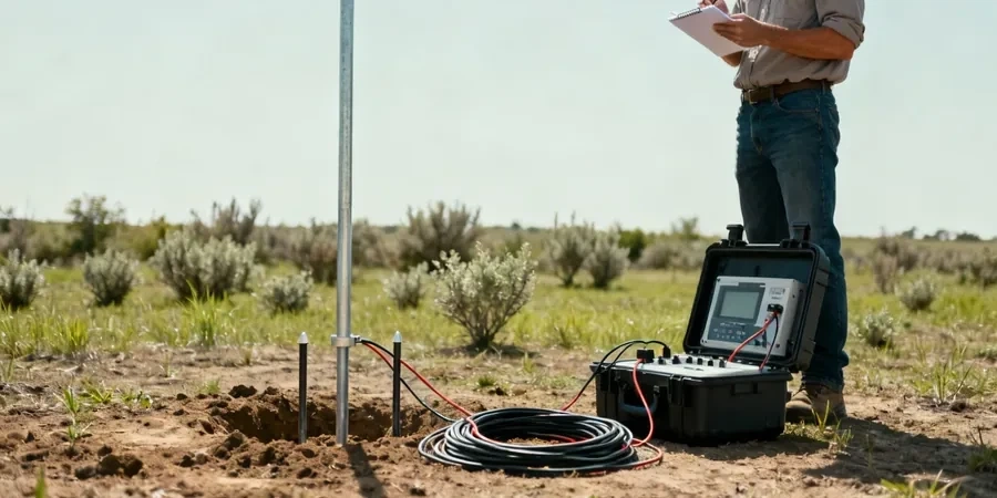
Newcastle’s subsurface is a layered archive of Permian and Triassic geology, but the 1989 earthquake reshaped more than the built environment — it reminded every engineer in the region that what lies beneath is never uniform. Electrical resistivity and Vertical Electrical Sounding (VES) cut through that uncertainty by delivering a continuous profile of apparent resistivity, which our team uses to differentiate saturated sand lenses, claystone seams, and competent rock before a single bucket enters the ground. In a city where the Merewether Conglomerate and the Lambton Formation can shift within meters, we rely on the MASW method to complement resistivity with shear-wave velocity data, giving us a solid two-parameter model for site classification under AS/NZS 1170.4. For projects near the Hunter River estuary or on reclaimed industrial land, you need more than borehole logs — you need a volumetric map of the subsurface that explains why resistivity contrasts exist and what they mean for foundation performance.
A resistivity contrast of 200 Ohm-m between a coal seam and surrounding tuff is not just a geophysical curiosity — it is a mapping tool that reduces exploratory drilling by thirty percent.
Area-specific notes
What we keep seeing in Newcastle, particularly around the Waratah–Mayfield corridor, is that historical mine workings and unrecorded backfill create resistivity lows that can be misinterpreted as natural clay layers by inexperienced operators. A water-filled drift in the Borehole Seam with a resistivity of 5–15 Ohm-m looks identical on a raw pseudosection to a saturated paleochannel fill, but the engineering consequence of mistaking one for the other ranges from expensive over-excavation to catastrophic collapse. The risk compounds when you skip resistivity and rely solely on a grid of boreholes: a 2-meter void between two perfectly logged drillholes will never appear on a log, yet it will show up as a sharp resistivity anomaly on a VES profile. We have also seen projects where saline groundwater intrusion from the harbour pushes background resistivity below 10 Ohm-m, effectively masking subtle lithological boundaries unless you run induced-polarization (IP) time-domain measurements as a secondary parameter. Our field crew approaches every VES line in Newcastle with the mindset that the data must be geologically plausible before it is mathematically acceptable, and we will re-run a sounding with a different array orientation if the inversion curve does not match the known dip of the local strata.
FAQ
How deep can a VES sounding penetrate in Newcastle's geology?
With a maximum AB/2 spread of 200 m, we typically achieve an effective depth of investigation between 40 and 60 m in the Coal Measures, depending on the resistivity contrast between the overlying claystone and the target coal seam. In saturated estuarine sediments near the harbour, the penetration depth drops to around 25–35 m because the low-resistivity (<15 Ohm-m) upper layer attenuates the current flow. We always run a preliminary sensitivity analysis using regional borehole data before committing to the final array length.
What is the typical cost of an electrical resistivity survey in Newcastle?
For a standard VES campaign with three to five soundings covering a typical residential or commercial lot, the investment ranges from AU$1030 to AU$1,520 depending on the maximum AB/2 required and the accessibility of the site. Larger 2D ERT profiles with multi-electrode cables and topographic survey support are quoted separately after a desktop review of the site geology.
Can resistivity surveys tell the difference between abandoned coal mine voids and natural cavities?
The electrical signature alone can be ambiguous: both air-filled voids and water-filled drifts produce resistivity anomalies, but the magnitude and shape of the anomaly differ. Air-filled cavities in the Borehole Seam typically show resistivities above 500 Ohm-m with a sharp lateral boundary, whereas water-filled workings sit in the 5–20 Ohm-m range and often present a broader anomaly due to conductive leaching. We resolve the ambiguity by integrating VES with ground-truth boreholes and, when necessary, running a short IP chargeability survey to discriminate between metallic-infrastructure noise and true geological targets.
How long does a VES survey take on site?
A single Schlumberger sounding with a 200-m AB/2 takes approximately 45 to 75 minutes of field time, including electrode layout, contact-resistance checks, and data acquisition at 20–30 logarithmic-spaced spacings. A 2D ERT line of 300 m length using 64 electrodes requires roughly two to three hours. The main variable in Newcastle is not the equipment but the site conditions: steep terrain in the Merewether Heights or traffic management on arterial roads can extend the setup time significantly.
What deliverables do you provide after a resistivity survey?
Our standard report package includes the raw apparent-resistivity curves, the inverted 1D resistivity models for each VES station, a 2D pseudosection when multiple soundings are collated, and a geological interpretation table that correlates resistivity units to the known stratigraphy of the Newcastle Coalfield. We also supply a site-class summary aligned with AS/NZS 1170.4 where relevant, and all data in digital format (RES2DINV and XYZ files) so your geotechnical engineer can re-process or integrate it directly into a BIM or GIS platform.